Satellite imagery supporting Network Rail’s Biodiversity Action Plan.
Earth Observation technologies provide valuable information on risk exposure to vegetation encroachment, landslides and floods. Network Rail and the UK Centre for Ecology and Hydrology have mapped habitats along the rail network using Copernicus Sentinel-2 satellite imagery. The data collected can be used in predicting the presence of species and in distinguishing diseased and healthy vegetation, supporting Network Rail’s Biodiversity Action Plan.
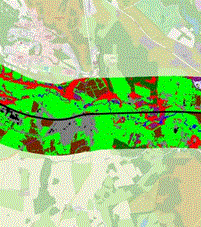
Currently in rail EO provides information on risk exposure with respect to vegetation encroachment, landslides, and floods, but in the next decade it is aspired to detect millimetre-scale ground movements, which will allow monitoring of track deformation and infrastructure health along the track (EUSPA, 2022). For instance, Network Rail (NR) together with the UK Centre for Ecology and Hydrology (UKCEH) have recorded all the habitats found along the rail network on a detailed map (see figure 1) using high-resolution and high-quality imagery from satellites. This information could then be used to predict the types of animals and plants likely to exist in these habitats. This project is part of NR’s new Biodiversity Action Plan, which targets to seize biodiversity net loss by 2024 and achieve a net gain by 2035 (Moore, 2021).

Figure 1: A map displaying all the habitats and their types along a rail track in the UK. (Network rail, 2021)
The Biodiversity Action Plan acts as a guidance to ensure habitat creation and maintenance and includes scenarios such as crown reduction, pollarding and coppicing of large trees, which are all substitutes to tree felling (UKCEH, 2021). The satellite technology will provide not only regular earth imagery to allow for habitat changes analyses, but also small area ground surveys in areas where rare species reside. Furthermore, UKCEH and Keen AI (a technology firm) aim to automate the process of identifying plant species based on images from on-train cameras through a new innovative technology (UKCEH, 2021). Through using multispectral imaging, they will be able to distinguish healthy and diseased vegetation given that healthy vegetation is likely to appear in red colours because it contains chlorophyll, which reflects near-infrared energy. In a case where the plants are invasive and diseased, ground survey might be potentially dangerous to humans, hence using a software will broaden our understanding of potential biodiversity threats in a safe and efficient manner.
Furthermore, EO has seen various applications in 16 other market segments and some like climate and environment can be particularly relevant to rail. For instance, ESA has reported the ability to detect floods versus newly burned land; snow versus ice versus clouds and capture water depth, vegetation coverage, soil moisture and the presence of fires. This can be achieved through using different combinations of wavelength bands to produce high-quality advanced multispectral imagining, which can highlight variations invisible to the human eye. Monitoring these processes feeds into an improved land management and can link to track-related challenges experienced in the rail industry (Dean, 2020).
July 2023
Back