BriteWay-XR
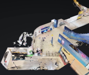
As part of Transport for Wales Lab Accelerator programme, Briteyellow created 360-degree virtual reality maps of three stations were created and converted into navigable grids using the BriteLocate GRID system to build an accurate model of crowd density across each station. An enhanced ultra-precision passenger tracking system was implemented and a high accuracy real-time crowd monitoring system was developed.
Using an app passengers can see a real-time status alert of station facilities with crowding updates and get a virtual reality tour of the station to check accessibility and plan their journeys ahead of time.
This approach brings familiarity to those who have never visited a station, helping to reduce anxiety, and provides actionable insights for transport operators and passengers. TRIG-A funding has enabled Briteyellow to improve the design of their sensors and has proven that the solution is technically feasible and can be deployed at scale. There are plans for extended user trials and a pilot with Transport for Wales, which is expected to increase customer satisfaction, reduce demand for passenger assistance and increase overall passenger demand.
November 2022
Back